Typhoon Fanapi, one of the strongest storms to hit China in years, has left 54 people dead and 42 missing in flooding and landslides in the south of the country, state media said Thursday.
Xinhua news agency said 79,000 people had been evacuated due to Fanapi, which hit China on Monday a day after raking Taiwan with heavy rains, killing two people and leaving more than 100 injured on the island.
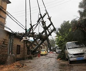
All of China's deaths occurred in the southern province of Guangdong, which has been battered by its worst rains in a century, it said.
Authorities in Guangdong had to use helicopters to air-drop relief supplies to victims in some areas, it added, quoting provincial flood control authorities.
Of those missing, 25 people disappeared in a rain-triggered mudslide, state media reports had said.
Typhoon-related disasters have destroyed more than 3,600 homes and caused economic losses in excess of two billion yuan (300 million dollars), Xinhua said.
Fanapi made landfall in Fujian province in the southeast but no casualties have been reported there.
The storm, which has weakened to a low-pressure system, has moved westward, bringing torrential rains in its wake and hitting Guangdong hardest.
At its strongest point, when it hit Taiwan on Sunday, Fanapi was packing winds of up to 220 kilometres an hour and dumped up to 100 centimetres of rain in the south of the island.
This summer, floods and related disasters triggered by torrential rains ravaged wide areas of China, killing more than 3,100 people and causing the evacuation of more than 15 million, according to government figures.
earlier related report
New tropical storm heads towards rain-soaked Central America
San Jose (AFP) Sept 23, 2010 – Tropical Storm Matthew formed in the southern Caribbean on Thursday, and threatened to strengthen into a hurricane as it headed west over warm water towards Central America.
The region is facing one of the most intense rainy seasons in the last 60 years, with flooding and landslides that have killed more than 300 people and caused serious damage.
Matthew is forecast to make landfall near the Nicaragua-Honduras border late Friday or early Saturday, and authorities are bracing for more flooding as soil across much of Central America is already saturated with water from the season's earlier storms.
At 2100 GMT, the center of Matthew was about 435 miles (700 kilometers) east of Puerto Cabezas, Nicaragua, packing maximum sustained winds of 40 miles (65 kilometers) per hour, with higher gusts, the Miami-based National Hurricane Center said.
"Additional strengthening is forecast during the next 48 hours, and Matthew could become a hurricane by Saturday," the NHC said, adding that the storm was moving towards the west at 16 miles (26 kilometers) per hour.
Matthew is expected to dump between six and 10 inches of rain over parts of Nicaragua and Honduras, with up to 15 inches possible in isolated areas.
"These rainfall totals may produce life threatening flash floods and mud slides," the NHC said.
A storm surge "is expected to produce some coastal flooding near and to the north" of the area the center of where Matthew makes landfall. "Near the coast, the surge will be accompanied by large and dangerous waves."
On its forecast track, the center of Matthew will graze the northern coast of Honduras, then cross water again in a northwesterly direction and strike Belize on Tuesday, and Mexico's Yucatan peninsula the following days.
Since the arrival of Tropical Storm Agatha in late May, heavy rain has caused destruction in Guatemala, Nicaragua, Honduras and El Salvador.
Costa Rica, Honduras and Nicaragua all declared states of alert. Only Panama will be spared in the region.
Guatemalan President Alvaro Colom declared a "state of national emergency" on Saturday due to the heavy rain and flooding. At least 36 people have been killed in Guatemala, 40 people are missing, and some 11,500 evacuated by the flooding, which has caused some 1.5 billion dollars in damage.
Share This Article With Planet Earth
