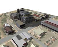
U.S. researchers say they've found a way to map and model three-dimensional representations of a city to address issues of growth and development. The method devised by University of Arkansas scientists has attracted the attention of the search-engine giant Google and the company SketchUp, both of which are examining the way software was used to create such huge data files.
The work resulted from what Snow Winters and Malcolm Williamson, two researchers at the university's Center for Advanced Spatial Technology, call a "3-D Mashup" — a merging of the geospatial techniques used for accurate mapping and the three-dimensional visualization and animation techniques for detailed visualization.
Students involved in the project included university student leaders Caitlin Stevens and Steven Reyenga, high school students Scott Ha, Celi Birke, Lorianne Gillespie and Kongmeng Xiong, and Upward Bound students Chris Cooley, Seth Koonce, Brandon Banks and Matt Reed.
The students gathered architectural, geospatial and photogrammetric data for 1,500 buildings in Fayetteville, Ark., and used the information to create accurate 3-D software models.
The study is detailed online at cast.uark.edu/local/cadis_crate_06/
Source: United Press International
