Researchers have developed new high-resolution satellite maps of the urbanization and other development surrounding the Chesapeake Bay watershed, in an attempt to help guide future land-use plans and policy.
The researchers, at the Woods Hole Research Center, created the maps – which cover the entire 168,000 square-kilometer (65,000 square-mile) watershed with the help of NASA's Land Cover Land Use Change program.
The way in which buildings, roads, parking lots and other components of the built environment are integrated into communities impact a wide range of biogeochemical and hydrological processes, the scientists said. Among other effects, increased pollution discharge into streams has significant implications for the health of ecosystems.
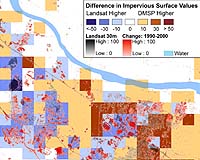
The new maps reveal areas of impervious surface cover, such as paved roads and parking lots, houses and buildings, for the Chesapeake Bay region, which has been highly altered by human land use, particularly over the past half-century.
"The information captured in these maps can be used to help mitigate impacts associated with the impervious nature of built environments, including reduced water quality, impoverished stream biota, and increased flood risk," said Scott Goetz of WHRC, lead author of an article in the current edition of Eos describing the work.
The team developed the maps for the region at 30-square-meter spatial resolution, and they currently are being used for baseline monitoring and modeling activities in the Chesapeake Bay Program restoration effort. The Eos article focuses on use of the regional maps to assess the quality of a new national impervious cover map available at coarser (one-square-kilometer) resolution for the entire contiguous United States.
"The national map provides a unique view of the built environment from which useful information relevant to water quality can be derived, particularly applications related to monitoring land transformation and assessing watershed impacts," said WHRC team member Patrick Jantz.
"These maps provide a unique view of the extent and intensity of the built environment, and the urbanization process which continues to rapidly evolve as exurban development expands into traditionally more rural areas," Goetz said.
The researchers hope the maps will provide baseline data to help environmental policy makers and plans, particularly those related to human modification of the landscape that have multiple impacts on aquatic ecosystems and water quality.
