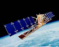
The Canadian Space Agency (CSA) today celebrated eight productive years in space with Radarsat-1, surpassing all expectations for a mission that was initially planned for five years. This premier Earth Observation satellite, Radarsat-1, has been maintained by the CSA Satellite Operations' team to enhance its ability to deliver accurate and timely images for the Government of Canada and a range of public and private sector clients located in more than sixty countries worldwide.
"Radarsat-1 continues to be a key component of the web of Earth Observation satellites," said CSA President Marc Garneau. "Its daily applications are innumerable in such domains as ice monitoring, forestry, cartography and oceanography. The reliability and accuracy of this satellite are extraordinary, helping Canada stand out for the quality and durability of its space hardware and specialized applications."
Radarsat-1 has literally mapped the world producing detailed reference maps of Antarctica, Canada, the contiguous United States and Africa and most recently has been used in emergency situations as part of the International Charter on Space and Natural Disasters. In the past year, it most notably provided images of the flooding in British Columbia that caused such extensive damage to the province.
Internationally, Radarsat-1 provided images of the Prestige oil spill near Spain's coastline and of the Stromboli volcanic eruption in Italy, demonstrating the range and utility of images produced by the satellite.
The launch of Radarsat-1's successor, Radarsat-2, is planned for the end of
2005. The satellite's structure and payload are developing well in the plants of subcontractors to MacDonald Detwiller and Associates (MDA), the project's main contractor. The commercialization of Radarsat-2 satellite data will be managed by MDA subsidiary Radarsat International (RSI), which provides data to some 20 certified ground stations throughout the world distributing images to over 600 clients globally.
