The northern and southern hemispheres of Mars differ fundamentally in terms of surface topography, age and morphology. In the north is an extensive lowland region that is relatively flat and much younger than the heavily cratered southern highlands. The transition zone between the two is characterised by a steep escarpment with an altitude difference of several kilometres. This region is referred to as the Martian dichotomy boundary.
The Nilosyrtis Mensae region is referred to as 'fretted terrain' and is characteristic of the transition zone between the highlands and lowlands on Mars. The numerous labyrinthine valleys that can be seen in these images are typical for such areas.
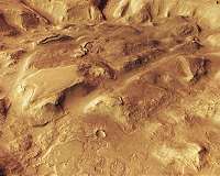
These images, acquired by the High Resolution Stereo Camera (HRSC) on board ESA's Mars Express spacecraft, show a landscape that has been heavily eroded by water, wind and ice. This is demonstrated by the many deep valleys and flattened crater rims. HRSC has been mapping Earth's neighbouring planet since 2004; it was developed and is operated by the German Aerospace Center (Deutsches Zentrum fur Luft- und Raumfahrt; DLR).
Rock glaciers once flowed down the valleys
The valley floors, especially in the northern parts of images 1, 4 and 5, show linear structures that follow the course of the valley. These 'lineated valley fills' suggest that ice-bearing material flowed slowly down the valley slopes and met in the centres of the valleys. Such debris-covered glaciers are similar to the rock glaciers that are found on Earth. Rock glaciers consist of ice mixed with debris and boulders. On Earth, they are mainly found in high-altitude permafrost regions or at polar latitudes.
The glacier-like deposits are possibly the remains of a receding ice sheet that covered the region during past ice ages. Earlier climate conditions on Mars apparently led to the deposition of larger amounts of snow and ice on the plateaus and in the valleys.
Erosion by water and ice has left rounded mountaintops and mesas in Nilosyrtis Mensae. Many of the terrain forms shown in the image have a soft-edged appearance, which is attributed to extensive overprinting by ice. The former impact crater (to the right in images 1, 4 and 5) became shallower and shallower over time due to the erosion of its rim and the deposition of eroded material and windblown sediment. The crater relief has now all but disappeared. The crater filling was in turn heavily eroded and carved up, giving it its present rugged appearance.
Water, wind and ice have changed the landscape dramatically
In contrast to the typical soft-edged terrain of this region, the south-western parts (top left) of images 1, 4 and 5 show rather sharp-edged structures. A sharp-edged linear structure several kilometres long, running almost north-south, is probably what is referred to as a dike.
This is the name given to a vertical cleft in the surrounding rock into which magmatic rock has penetrated, and which now protrudes at the surface due to its greater resistance to erosion. To the west of it (above, in the image) is a tangle of intersecting structures, which also have sharp-edged ridges. These are most likely solidified infillings of cracks in the rock. Water once seeped through this rock, washing out various minerals, which then 'fell out' into the cracks and solidified.
The former, dried-up river valley in the south of the image (left) was eroded by constantly leaking groundwater, which can be seen from the broad, semi-circular valley heads. At wider points on the valley floor further downstream (in the centre/left of the image), smaller river courses have cut into the lineated valley fill. This points to repeated, episodic fluvial activity in this region.
