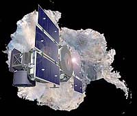
The Ice, Cloud and Land Satellite (ICESat) built by Ball Aerospace and Technologies Corp. will continue operations until at least 2010 following a NASA mission extension contract. ICESat, designed for a three-year lifetime with a five-year goal, was launched Jan. 12, 2003. The Ball Commercial Platform (BCP) 2000 employed for ICESat was built under contract to NASA's Rapid Space Development Office (RSDO).
"The ICESat BCP has demonstrated that it can meet the demanding rigors of environmental and remote-sensing requirements and joins other Ball spacecraft in consistently exceeding lifetime minimum requirements," said Cary Ludtke, vice president and general manager for Ball's civil and commercial business unit.
ICESat has made significant contributions to the measurement of ice sheet elevation, cloud and aerosol heights, as well as land topography and vegetation characteristics. The mission provides multi-year elevation data needed to determine ice sheet mass balance and cloud property information, and provides topography and vegetation data from around the globe as well as polar-specific coverage over the Greenland and Antarctic ice sheets.
ICESat began its fourteenth science campaign return on Saturday, Feb. 16, following calibration tests that further improve pointing. The mission currently collects laser returns for approximately 30 days at three- to six-month intervals.
During each orbit, the spacecraft's Geoscience Laser Altimeter, built by Goddard Space Flight Center, points at the same ground track as it passes over the polar regions and Greenland. The observing campaign also requires the spacecraft to point at approximately 10 targets of opportunity and return several ocean scans daily.
In addition to ICESat, the Ball Aerospace's QuikSCAT, and the NPOESS Preparatory Project (NPP) spacecraft, were also RSDO procurements.
