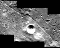
This mosaic of three images, taken by the advanced Moon Imaging Experiment on board ESA's SMART-1 spacecraft, shows the crater Mersenius C. AMIE obtained this sequence on Jan. 13 from distances of 1,149 kilometers, 1,172 kilometers and 1,195 kilometers (712 miles, 727 miles and 741 miles), respectively.
The ground resolution ranges from 104 meters to 108 meters (338 feet to 351 feet) per pixel. All images are located at a longitude of 45.7 degrees west longitude and at latitudes of 21.3 degrees, 19.7 degrees and 18.1 degrees south, respectively.
Mersenius C is positioned in the highland area between Mare Humorum and the Oceanus Procellarum. The crater has a diameter of 14 kilometers (8.7 miles) and is best visible for ground-based observers four days after the lunar first quarter.
The crater is named in honor of Marin Mersene, a French philosopher and physicist (1588-1648). The crater is surrounded by a system of grabens, which are fractures that form when the lunar surface sinks slightly as a result of faults.
