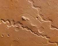
ESA's Mars Express orbiter captured this image with its High Resolution Stereo Camera that shows the Nanedi Valles valley system, a steep-sided feature that may have been formed in part by free-flowing water.
The HRSC actually obtained the image on Oct. 3, 2004, during orbit 905 at a ground resolution of approximately 18 meters (59 feet) per pixel, but ESA has not released it until now. The image has been rotated 90 degrees clockwise, so that north is to the right.
It shows Nanedi Valles, a roughly 800-kilometer (500-mile) valley extending southwest-northeast and lying at approximately 6.0 degrees North and 312 degrees East in the region of Xanthe Terra, southwest of Chryse Planitia.
Nanedi Valles ranges from approximately 0.8 kilometers to 5.0-kilometers (0.5 mile to 3.1 miles) wide and extends to a maximum of about 500 meters (1,625 feet) below the surrounding plains. The valley is relatively flat-floored and steep-sloped, and exhibits meanders and a merging of two branches in the north.
The origin of these striking features remains heavily debated, ESA said in a statement Monday. Some researchers think erosion caused by ground-water outflow created them, while others suggest flow of liquid beneath an ice cover or collapse of the surface in association with liquid flow could have been responsible for the valley's formation.
The debate continues, but it seems likely some sort of continuous flow rather than a single flooding event created these features, ESA said.
By studying Nanedi Valles, scientists hope to learn more about the climatic evolution of the red planet. The stereo and color capabilities of the HRSC camera reveal details about Martian morphology, and allow researchers to analyze reflected light at different wavelengths to determine the various geologic units within a scene.
The color image was derived from the three HRSC's color channels and the nadir channel. For use on the Internet, image resolution has been decreased.
