Opportunity is healthy and has been making excellent progress around "Erebus Crater." At the beginning of the week, the rover was in automode as it was still recovering from a partial uplink, but on sol 614 the team sent a real-time activate command and the rover performed remote sensing.
The team is no longer operating under restricted sols, and Opportunity traveled 101.65 meters (333 feet) in four sols. The rover is generally heading westward around the crater, but traveled northward on sol 618 to avoid some larger ripples to the west.
Sol-by-sol summaries
Sol 613 (Oct. 14, 2005): The team planned untargeted remote sensing. However, the master sequence did not run because Opportunity was in automode.
Sol 614: The team sent a real-time command to activate the sol 614 master sequence. The plan included remote sensing.
Sol 615: Opportunity completed an 18.5-meter (61-foot) drive heading westward around Erebus Crater.
Sol 616: Opportunity drove 24 meters (79 feet), with an average slip of 2.3 percent.
Sol 617: The rover completed a 43.65-meter (143-foot) drive, zigzagging around low points in the ripples.
Sol 618: Opportunity completed a 15.5-meter (51-foot) drive on outcrop, heading northward to find some lower ripples to cross.
As of sol 618 (Oct. 19, 2005) Opportunity has driven 6,138.07 meters (3.81 miles).
Opportunity Skirts Rover-Eating Dunes To Get Closer To Mogollon Rim
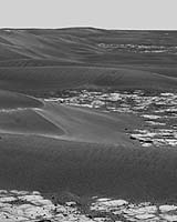
Ithaca NY (SPX) Oct 25 – Meanwhile Steve Squyres the principal investigator for the MERs reports: Opportunity was the star of the show this week. One piece of news, of course, is that we're really driving again. Erebus is a nasty place to work, with widely-separated outcrops of rock separated by lots of dunes and drifts, some of which look like they could be real rover-eaters. But we're getting the hang of driving in this stuff, and we made some very solid progress toward the Mogollon Rim this past week.
On top of that, Opportunity has stumbled onto something really new and different lately… the blueberries seem to be gone! We've been seeing smaller and smaller berries in the rocks since all the way back at Strawberry and Lemon Rind, two of the rocks we looked at before we got on the Erebus Highway. So we've known something was going on for awhile.
But if you look at the most recent images — the front Hazcams from Sol 617 are a great example — you'll see that the rocks here appear to be lacking berries altogether. We can't say that they're gone completely… we really need some better imaging, including MI images, to do that. But this sure doesn't look anything like the berry population back at Eagle or Endurance.
We haven't done any IDD work on this stuff yet, but that'll be coming soon. And it's such a new discovery that it's too early yet to say exactly what it means. But one possible guess at this point is that we have moved "up section" in geologic terms — to rocks that are higher up in this stack of layered sediments — and that the rocks at this level never experienced the concretion-forming process.
It's an interesting hypothesis with interesting implications, and it's also one that could explain a few other odd things we've been thinking about ever since Eagle crater. We're not jumping to any conclusions, but everybody is itching to get the IDD onto this stuff as soon as we get the chance.
At Gusev, Spirit is working her way nicely down the upper portion of Haskin Ridge. We're within a few tens of meters of the top of the step now, and we've stopped for a bit of IDD work on a new outcrop called Kansas. No idea what it's made of yet, but we should get some clues over the next couple of days.
