US weather monitors issued a hurricane watch for the southeastern tip of Florida on Sunday as a fresh tropical storm began to brew in the western Atlantic.
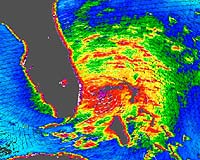
Satellite data showed a tropical depression – the phenomenon that leads to a tropical storm and can escalate to a hurricane – centered 625 kilometers (390 miles) southeast of Nassau, the Bahamas, the US National Hurricane Center said.
It issued a hurricane watch for all of the Florida Keys and the northwestern Bahamas, meaning that these areas could experience hurricane conditions by late Monday.
As of midday Sunday, the depression had maximum sustained winds of 55 kph (35 mph), and may strengthen to a tropical storm by late Sunday, moving westward at nearly 20 kph (12 mph), the Center said in an advisory.
Hurricane Katrina, rated four on a storm scale whose maximum is five, struck Louisiana, Mississippi and Alabama on August 29, killing at least 880 people and leaving hundreds of thousands homeless.
That was followed by Hurricane Ophelia, a category one storm, which last week touched the North Carolina coast, on the eastern US seaboard, causing some property damage and localised flooding before fizzling out at sea.
Experts say 2005 may be the worst season on record for hurricanes. The six-month season ends on November 30, and late hurricanes are typically more violent than early-season ones.
