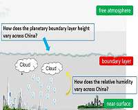
Model-simulated factors of importance can fill the gaps in surface observation-based estimates of fine-particulate-matter concentrations, providing a data basis for the long-term analysis of meteorological parameters [e.g., planetary boundary layer height (PBLH) and relative humidity (RH)] at the national scale.
Dr. Yidan SI and Associate Professor Shenshen LI, from the Institute of Remote Sensing and Digital Earth, Chinese Academy of Sciences, used ground-observed data to validate the GEOS-5-assimilated PBLH and RH released by NASA's Global Modeling and Assimilation Office. They found that, overall, the simulated RH was consistent with the statistical data from meteorological stations, while the simulated PBLH was underestimated compared to LIDAR data by a factor of approximately two.
They further examined the spatiotemporal distribution characteristics of two factors in four regions–North China, South China, Northwest China, and the Tibetan Plateau. Dr. Yidan SI explains their findings, which have been published in Advances in Atmospheric Sciences,
"The annual PBLH trends in all regions were fairly moderate but sensitive to solar radiation and precipitation, which explains why the PBLH values were ranked in order from largest to smallest as follows: Tibetan Plateau, Northwest China, North China, and South China. There was a strong seasonal variation of PBLH, with high values in summer and low values in winter, which was also consistent with the turbulent vertical exchange. Not surprisingly, the highest RH was in South China and the lowest RH in desert areas of Northwest China (less than 30%). Seasonally, South China exhibited little variation, whereas Northwest China exhibited its highest humidity in winter and lowest humidity in spring. The maximum values in the other regions were obtained from July to September."
Associate Professor Shenshen LI further explains that these two factors are also important for estimating near-surface particulate matter concentrations, filling the gaps left by the lack of extensive ground observations by virtue of the simulations of chemical transport models.
How do high-frequency oscillations of tropical cyclones vary across the W North Pacific?
Beijing, China (SPX) Feb 27 – High-frequency oscillations, with a period of approximately two hours, generally occur within the eyewall of tropical cyclones. These oscillations in turn induce oscillations of the tropical cyclone intensity through the oscillation of convection.
Associate Researcher Shumin CHEN, Professor Weibiao LI and their team, from the School of Atmospheric Sciences, Sun Yat-Sen University, simulated several tropical cyclones using mesoscale numerical models. As detailed in their paper, recently published in Advances in Atmospheric Sciences, they found that periods of high-frequency oscillations of tropical cyclones in the South China Sea are significantly shorter than those in the open water of the western North Pacific.
They further examined the dynamic and thermodynamic characteristics of all the tropical cyclones. Associate Researcher Shumin CHEN explains their findings:
"We examined the environmental vorticity, divergence, thermal winds, and the convergence winds in the lower layer. We found that the general features were similar in tropical cyclones in the South China Sea and the open western North Pacific, except that the convergence within the lower layer of tropical cyclones in the South China Sea was significantly larger than that in the open western North Pacific. Convergence enhanced by greater terrain friction in the South China Sea strengthened the disturbance and then contributed to the shorter oscillation periods".
Professor Weibiao LI further explains that the study reveals the variations of high-frequency oscillation over different sea areas, and helps to improve the prediction of tropical cyclone intensity in different sea areas over the western North Pacific.
