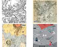
A catalogue that provides a complete overview of over 2,200 planetary maps produced worldwide between 1600 and 2018 were presented at the European Planetary Science Congress (EPSC) 2018 in Berlin. The catalogue has been produced by Henrik Hargitai, from Eotvos Lorand University in Budapest, and Mateusz Pitura, from the University of Wroclaw in Poland.
"Production of planetary maps started in Europe in the 1600s. It expanded to the United States and the Soviet Union in the 1960s and, more recently, has spread to China and Japan," said Hargitai.
"Over time, mapping has become less coordinated and more diverse, so that today it is becoming challenging to oversee the proliferation of spatial data published in different countries by institutions, individual researchers and, increasingly, citizen scientists. A common database is needed."
To provide this definitive overview, Hargitai and Pitura have created the open access "International Catalogue of Planetary Maps," available here and through the International Cartographic Association's Commission on planetary cartography. The data can be filtered by author, year, country, scale and type and reveal long-term trends in planetary mapping and planetary science activities.
Recent web-based map services, such as MoonTrek by NASA/JPL/Caltech or OpenPlanetaryMap's basemap of Mars, are organised into layers, so that the user can view and analyse surfaces in detail with Geographic Information System (GIS) tools.
Although most of the maps in the catalogue show Mars and the Moon, almost all the major bodies of the solar system are represented, including Mercury, Venus, Ceres, and the satellite systems of Jupiter, Saturn and Pluto.
"Our catalogue is being updated regularly with both newly resurfaced historic maps and new additions. For the future, we plan to add maps that have been published in journal articles and digitize maps that do not yet include GIS formats," added Hargitai.
"Maps are used for mission planning, surface operation and post mission analysis. In the near future they will be key components of planning and operating new human missions. We live in a transition period where static maps that characterized the last 400 years may become extinct, replaced by dynamic digital map services and tools."
