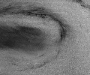
The German Aerospace Center radar satellite TerraSAR-X looked right into the eye of Typhoon Megi while it was in the middle of the South China Sea. The image, acquired on 21 October 2010, shows the tropical cyclone on its way to Taiwan after raging through the Philippines. Megi is one of the fiercest typhoons this region has seen in recent years.
TerraSAR-X managed to capture the typhoon near North Vereker Bank, a small island in the South China Sea. "It's not easy to capture the eye of a typhoon," says Stephan Brusch from the DLR Remote Sensing Technology Institute.
"Fortunately, the typhoon wasn't moving very quickly and the path predictions were excellent." Using the US meteorological service's forecast of the typhoon's route, DLR researchers were able to prepare TerraSAR-X to acquire its image in the right place and at the right time.
Inside the eye of the storm, the water is extremely calm – there is no rain or wind to ripple the surface. This means that hardly any radar signals get returned to the satellite but are reflected off to the side instead.
This is why TerraSAR-X portrays the eye of Megi as a black area, unlike the parts where white rings form a circle – this is where the wind produces a strong wave pattern and the rough surface reflects the majority of the satellite's radar signals back to it.
A typhoon's wind speed is at its maximum around the eye – Megi's winds reached around 250 kilometres per hour at the time of image acquisition. This led to the typhoon being declared a level-5 storm on the Saffir-Simpson scale, with water levels rising by over 5.5 metres.
Patterns on the water
In the direct vicinity of the typhoon, the TerraSAR-X images show heavy cumulus clouds, impeding even the radar satellite's imaging capability with their large ice crystals and extreme height.
You can spot these in the image by their almost granular texture. From space, the crests of the powerful waves appear as patterns on the surface of the water. From its orbit, about 500 kilometres above Earth's surface, TerraSAR-X was able to detect ships sailing on the turbulent South China Sea during the typhoon.
The radar satellite captured images of an area 100 kilometres wide. "The eye of the typhoon must be about 40 to 50 kilometres in diameter," estimates DLR researcher Brusch. The typhoon reached the Philippines in mid-October and devastated vast areas. According to official reports, 36 people lost their lives. Megi then moved over Taiwan, bringing enormous amounts of rainfall.
Landslides claimed 13 lives here, according to news agency reports. Only after arriving on the Chinese mainland did the typhoon subside and become significantly weaker.
Share This Article With Planet Earth
