Just as Chinese warplanes have been testing Japan in the skies over the South Pacific, it now looks like Taiwanese drones are getting set to test Japan, too – for an opportunity. Taiwan drone maker Uaver thinks it sees an opening in Japan for its fixed-wing unmanned aerial vehicles (UAVs), which combine advanced carbon fiber and avionics technology to make durable, speedy, hand-launchable drones capable of long flight times for terrestrial surveying and mapping.
Military-use drone makers are not uncommon in Taiwan, and include such noteworthy names as Chung-Shan Institute of Science and Technology (CSIST), National Cheng Kung University, and Gang Yu Corp. Nine-year old Uaver sports engineers who designed jet fighters for Taiwan's Air Force. They have integrated some hard-core features into its civilian-use drone lineup, including snow and rain protection, simultaneous dual photo and video recording capabilities, automatic frequency hopping, and advanced signal processing to improve scanning accuracy.
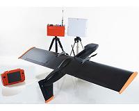
Uaver's flagship product is the twin-engine, electrically powered Avian RTK. With a 1.90 meter wingspan and 4.8kg maximum weight, it is capable of speeds up to 81kph and a 90 minute flight time, and can be fitted with a variety of photographic and scanning equipment. It is launched by bungee cord and retrieved by parachute.
Uaver general manager David Lin brought an Avian and other kits to Japan for the 1st annual International Drone Expo last spring to kick off his company's maiden foray into the local market. With business in China, Korea, Thailand and elsewhere in Asia, Japan is the only regional market left to crack, he says.
"Like a lot of other manufacturers, we are waiting for Japanese government regulations over frequency use, altitude, and allowable flight zones to loosen," he says. "Once they do, we think clients will be interested in what we have to offer."
Uaver is most confident in its RTK (Real-Time Kinematic) positioning technology, which has garnered international repute when paired with its PPK (Post Processed Kinematic) software. RTK capabilities are provided by the various Global Navigation Satellite Systems (GNSS), and allow for basic aerial mapping tasks. PPK software allows received signals to be stored and adjusted with secondary reference data, greatly enhancing accuracy.
For sensitive mapping tasks, the difference between non-PPK and PPK results can be crucial. "PPK allows the user to analyze more thoroughly the integrity of a computed position," says Machine Control Online's Joe Sass, noting that the software is usually offered at extra cost. But this cost is a pittance compared to the dollars that might be saved by avoiding costly mistakes, he adds.
The Avian has been used in monitoring natural disasters in Taiwan and Thailand. Flying at an altitude of 200-300 meters, a DSLR camera-equipped Avian can achieve ground sample distance (GSD) – a measure of aerial photographic accuracy – up to 5cm.
A typical Avian kit runs about $50,000 per copy, but can be mastered with little training, another benefit, says Mr. Lin. The drone can be operated in complete autonomous mode, or very simply using a gamepad to control heading.
"The whole package is designed for somebody with little to no flying experience, which we think will appeal to first-time buyers," he says.
