This time of year in Wales is known to locals as the "muirburn" season. "Muirburn" is a Scottish variant of the word moorburn which is the burning of the heather moors in the countryside to remove old growth.
The Government allows fires (by permit) on the moorlands before an all-burn ban which begins around mid-April. This is part of moorland management much like other countries employ to clear out undergrowth to reduce fire fuels and to prepare for the fire season when the temperatures rise and the humidity lowers.
The Welsh government officials in land management ensure conditions are right for controlled burns by consulting satellite imagery. They are just one of many, many countries that employ this method of land management. Controlled burns should not be confused with wildfires, however.
The wildfires that have broken out in various places in Wales and Britain were most likely due to climate change which is bringing warmer temperatures to the area earlier in the year.
The higher temperatures that have trended in February of this year have caused the undergrowth to dry out earlier which in turn creates an unsafe environment where one spark can bring about an inferno. Where there's fire there's smoke and that introduces yet another serious issue to consider.
The smoke released by any type of fire is a mixture of particles and chemicals produced by incomplete burning of carbon-containing materials. All smoke contains carbon monoxide, carbon dioxide and particulate matter (PM or soot).
Exposure to high levels of smoke should be avoided especially those individuals with cardiovascular or respiratory conditions (e.g., asthma), fetuses, infants, young children, and the elderly may be more vulnerable to the health effects of smoke exposure.
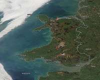
NASA's Earth Observing System Data and Information System (EOSDIS) Worldview application provides the capability to interactively browse over 700 global, full-resolution satellite imagery layers and then download the underlying data. Many of the available imagery layers are updated within three hours of observation, essentially showing the entire Earth as it looks "right now."
This satellite image was collected on Feb. 28, 2019 with NASA's Aqua satellite. Actively burning fires, detected by thermal bands, are shown as red points. Image Courtesy: NASA Worldview, Earth Observing System Data and Information System (EOSDIS).
