There are few places on Mars lower than this. The floor of Melas Chasma sinks nine kilometres below the surrounding plains. New images from the German Aerospace Centre (Deutsche Zentrum fur Luft- und Raumfahrt; DLR) operated High Resolution Stereo Camera on ESA's Mars Express orbiter highlight the complex history of this enormous martian canyon.
Melas Chasma is part of the huge Valles Marineris rift valley, which stretches for more than 4000 kilometres. Around Melas Chasma, there is abundant evidence for water having flowed on Mars in the past. Apart from ancient water-cut channels, there are lighter-coloured deposits of sulphate components that were probably deposited in a former lake.
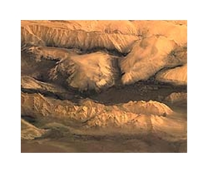
The sides of the valley show evidence of multiple large landslides that have created vast fan shapes of material. This debris appears rough and jumbled, contrasting with the underlying smoother surface visible further in the basin. The rocks display flow textures indicating that they were once deposited by liquid water, water ice or mud.
The difference from the floor to the plateau is more than 9 km. But on Mars, what does one measure elevations against? On Earth, we use sea level. For Mars, planetary scientists have derived an average shape and size for the planet based on spacecraft observations. They call this the 'areoid' and use its surface as the equivalent of sea level.
In the case of Melas Chasma, the deepest portions of the canyon are 5 km below the areoid, whilst the surrounding plateau rises to elevations of 4 km above.
A few ancient valleys have been preserved on the high plateau at the top of the cliff. The orientation of the largest one is parallel to the edge of the cliff, which may indicate that the valley originally followed an old fault line. Remaining faults are probably the main reason for the instability of the flanks, which have frequently collapsed forming huge landslides.
The High Resolution Stereo Camera (HRSC) experiment on the European Space Agency's Mars Express mission is led by the Principal Investigator (PI) Prof. Dr Gerhard Neukum, who was also responsible for the technical design of the camera.
The science team of the experiment consists of 45 Co-Investigators from 32 institutions and 10 nations. The camera was developed at the German Aerospace Center (DLR) under the leadership of the PI, G. Neukum, and built in cooperation with industrial partners (EADS Astrium, Lewicki Microelectronic GmbH and Jena-Optronik GmbH).
The experiment on Mars Express is operated by the DLR Institute of Planetary Research, through ESA/ESOC. The systematic processing of the HRSC image data is carried out at DLR.
The scenes shown here in detail were processed by the PI-group at the Institute for Geosciences of the Freie Universitat Berlin in cooperation with the DLR Institute of Planetary Research, Berlin.
Share This Article With Planet Earth
