A hurricane seethed off the eastern coast of the United States on Sunday, triggering a storm warning for a swathe of coastline and prompting local authorities to suspend aid to victims of Hurricane Katrina, which less than two weeks earlier devastated parts of three southern US states.
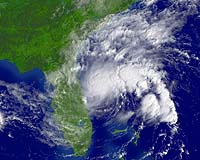
The National Hurricane Center issued the warning for a 360-kilometer (225-mile) stretch of coastline from the South Santee River in South Carolina to Cape Lookout in North Carolina, as Hurricane Ophelia swirled in the Atlantic, some 400 kilometers (250 miles) away.
Ophelia "is stationary and a slow west-northwestward motion is expected over the next 24 hours," the Center said.
The alert means that tropical storm conditions could hit the warning area by late Monday, and hurricane conditions are possible by early Tuesday, the Center's advisory said.
Ophelia is rated one on a five-point hurricane scale where five is the severest. A category one hurricane packs maximum sustained winds of 119-153 kilometers per hour (74-95 miles per hour), with a storm surge of about 1.5 metres (4-5 feet) above normal.
In contrast, Katrina, which slammed into the Gulf Coast on August 29, wreaking havoc to parts of Louisiana, Mississippi and Alabama, was a far more powerful category four storm, with sustained winds hitting a maximum of 210-249 kilometers per hour (131-155 miles per hour), and surges of four to five metres (13-18 feet) above normal.
The estimated one million people displaced by Katrina have been spread all over the country, but South Carolina has suspended flights of evacuees so it can prepare for the new hurricane.
Some of the hundreds of families moved from Louisiana to coastal districts of South Carolina after Katrina's deadly strike are now thinking of moving on again because of Ophelia.
At least 700 Katrina evacuees have been airlifted to the inland South Carolina cities, Columbia and Greenville, in recent days, said Chris Drummond, a spokesman for Governor Mark Sanford.
Eddie King, emergency management director in Pender County, North Carolina, said he had to withdraw offers of help to Katrina-affected regions.
The storm forecast has Ophelia potentially hitting his county Tuesday.
"We are walking right into the middle of hurricane season," King said. "It's not that we don't want to help anybody. But we felt like we had to make sure that we could face any problems that arise here."
With the United States bracing for years of rebuilding, the Atlantic hurricane season is far from over and more major storms are predicted.
"The tropics are only going to get busier as we enter the peak of the season," said David Johnson, director of the US National Weather Service.
If the 2004 season was exceptional, with four hurricanes hitting Florida, experts said this storm season could turn out to be even worse.
"We expect that by the time the 2005 hurricane season is over, we will witness seasonal tropical cyclone activity at near-record levels," said William Gray, Colorado State University professor of atmospheric science. Cyclones and hurricanes are synonymous.
"We are continuing the bad news by predicting above-average activity for September and October," Gray said.
Hurricane season has almost two months to go, but, Gray said, we have had more than a full season's worth of activity.
"We have already experienced 110 percent of the average full-season net tropical cyclone activity," he said.
The season got off to a running start, with two hurricanes in June. Those June hurricanes were also more intense than in any previous year. Dennis and Emily reached category four, on the five-step Saffir-Simpson scale.
Kerry Emanuel, an expert at the Massachusetts Institute of Technology, has tracked five decades' worth of hurricane data and found that these storms are getting stronger and lasting longer.
He chalks the difference up to global climate change. Warm waters fuel hurricanes, and as oceans get warmer, storms will become stronger, he said, although he could not say if their frequency will increase.
