Hurricane Ivan is the most powerful hurricane to hit the Caribbean in 10 years. On September 7 and 8 it damaged 90 percent of the homes in Grenada and killed at least 16 people as it swept over Grenada, Barbados and the other islands in the area.
By Thursday morning on September 9, Ivan's sustained winds reached 160 mph making it a rare category 5 hurricane on the Saffir-Simpson scale. By Monday September 13, Ivan is blamed for 67 deaths and is bearing down on western Cuba. Ivan's winds are 160 mph with higher gusts.
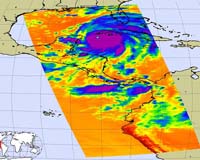
These images of Hurricane Ivan were acquired by the AIRS infrared, microwave, and visible sensors on September 13 at 1:30 pm local time as the storm closes in on western Cuba.
Ivan's winds at category 5 strength are sustained at 160 mph (260 km/hr) and extend out to 105 miles from the center.
Tropical-storm force winds are up to 205 miles from the center. The infrared image shows that the eye has grown quite large – perhaps 40 km (25 miles) across – which is sometimes an indication of weakening but may not be in this case.
The surface pressure at the time of this image was estimated by the National Hurricane Center at 915 mb and falling – consistent with a very intense and strengthening hurricane.
The image above shows how the storm looks through an AIRS Infrared window channel. Window channels measure the temperature of the cloud tops or the surface of the Earth in cloud-free regions.
The lowest temperatures are associated with high, cold cloud tops that make up the top of the hurricane. The infrared signal does not penetrate through clouds, so the purple color indicates the cool cloud tops of the storm.
In cloud-free areas, the infrared signal is retrieved at the Earth's surface, revealing warmer temperatures. Cooler areas are pushing to purple and warmer areas are pushing to red.
