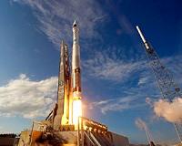
Aerojet Rocketdyne supported the launch of the WorldView-3 commercial remote sensing satellite into orbit – the fifth launch in six weeks. The mission was launched from Vandenberg Air Force Base in California aboard a United Launch Alliance (ULA) Atlas V rocket for Lockheed Martin Commercial Launch Services.
Aerojet Rocketdyne launch vehicle propulsion included an RL10A-4-2 upper-stage engine, a dozen attitude control thrusters and six helium pressurization tanks.
"The tempo of successful launches into orbit is testament to the dependability and reliability of our propulsion systems, and we look forward to working with our customers to ensure uninterrupted access to space," said Steve Bouley, vice president of Space Launch Systems at Aerojet Rocketdyne.
After the Atlas V lifted off the pad and the Centaur upper stage separated from the launch vehicle, a single RL10A-2 engine ignited to place the payload into orbit, helped by the Centaur thrusters and other Aerojet Rocketdyne-provided hardware for both the booster and upper stage.
The RL10A-4-2 engine delivers 22,300 pounds of thrust to power the Atlas V upper stage, using cryogenic liquid hydrogen and liquid oxygen propellants during its operation. ARDE, a subsidiary of Aerojet Rocketdyne based in New Jersey, provides the pressure vessels on the first and second stages on the launch vehicle.
Twelve Aerojet Rocketdyne monopropellant (hydrazine) thrusters in four modules on the Atlas V Centaur upper stage provided roll, pitch and yaw control as well as settling burns.
WorldView-3, owned and operated by DigitalGlobe, is the first multi-payload, super-spectral, high-resolution commercial satellite for Earth observations and advanced geospatial solutions.
It is designed to collect up to 680,000 square kilometers of imagery per day, and sense both the visible spectrum as well as deeper into the infrared spectrum.
The satellite will carry an atmospheric instrument called CAVIS (Cloud, Aerosol, water Vapor, Ice, Snow). Built by Ball Aerospace and Technologies Corp., CAVIS is designed to monitor the atmosphere and provide correction data to improve satellite imagery when it images Earth objects through haze, soot and dust.
