|
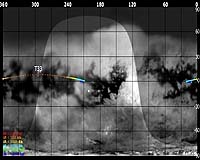
Paris, France (ESA) Jun 28, 2007 This Friday, 29 June 2007, Cassini returns to Titan for its thirty-fourth targeted encounter with Saturn's largest moon: Titan-33. The closest approach occurs at 16:59:46 UT, at an altitude of 1932 kilometres above the surface and at a speed of 6.2 kilometers per second. The latitude at closest approach is 8.1N and the encounter occurs on orbit number 47. This encounter is set up with two manoeuvres: an apoapsis manoeuvre on 21 June, and a Titan approach manoeuvre on 26 June. This is the last in a series of nine outbound Titan encounters and occurs less than two days after closest approach to Saturn.
Science Highlights Cassini Plasma Spectrometer T33 is a polar and upstream encounter. Though some CAPS scientists find wake encounters more desirable, the upstream encounter allows a very good comparison to wake encounters such as T9. There will be good CAPS pointing for magnetospheric interaction, with corotation in view from closest approach-2 to closest approach+1 hour. There will be no turns during this interval, allowing for very stable CAPS pointing during this period. The lack of turns also simplifies data analysis over the several minutes needed to get a full 3-D distribution - no concern that the spacecraft is turning, which would complicate the analysis. The team anticipates a good data set for ionosphere and polar upsteam interactions Ultraviolet Imaging Spectrograph (UVIS) The team will obtain spectral images of Titan in the EUV and FUV to map the aurora and dayglow, to map hydrocarbon absorption, and to measure scattering and absorption by aerosols in the stratosphere Composite Infrared Spectrometer (CIRS) CIRS will perform high spectral resolution measurements of the atmosphere Visual and Infrared Mapping Spectrometer (VIMS) VIMS will obtain a global composition map at nearly full illumination and will perform monitoring for cloud motion and formation. VIMS will be searching for spectral signatures of dune fields, liquid hydrocarbons, and water and methane frost Imaging Science Subsystem (ISS) ISS will be performing high-resolution (120-240 m/pixel) imaging of the equatorial bright-dark boundary around 1N, 215-210W (low phase angle coverage - 20-15 degrees), and will do regional-scale (240-500 m/pixel) mapping of the equatorial bright-dark boundary around 1N, 210W (very low phase angle ~13) Email This Article
Related Links
 Pasadena CA (JPL) Jun 15, 2007
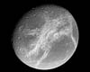
Saturn's moons Tethys and Dione are flinging great streams of particles into space, according to data from the Cassini mission to Saturn. The discovery suggests the possibility of some sort of geological activity, perhaps even volcanic, on these icy worlds. |
|
| The content herein, unless otherwise known to be public domain, are Copyright 1995-2006 - SpaceDaily.AFP and UPI Wire Stories are copyright Agence France-Presse and United Press International. ESA PortalReports are copyright European Space Agency. All NASA sourced material is public domain. Additionalcopyrights may apply in whole or part to other bona fide parties. Advertising does not imply endorsement,agreement or approval of any opinions, statements or information provided by SpaceDaily on any Web page published or hosted by SpaceDaily. Privacy Statement |