|
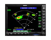
Olathe KN (SPX) Mar 20, 2006 Garmin International has announced the GMX 200, a multi- function display (MFD) for pilots demanding the ultimate in situational awareness. The GMX 200 raises the bar and includes a high resolution (640 x 480 pixels) display with a viewing area that is almost 20% larger than other panel mounted MFD units. An advanced backlighting scheme dramatically improves the color and contrast, resulting in chart depictions and images that are brighter and more vivid in all lighting conditions. Building on the success of Garmin's MX20, the next generation GMX 200 has multiple functions and useful features. At a glance you see your aircraft's position relative to terrain, obstructions, weather, airways, navaids, restricted airspace and more. With a simple press of a soft key the pilot can select between several charting options and easily add or remove details. A new rotary knob has been added to allow for quicker map scale changes and entry of data. In addition, a new front loading SD card-slot allows for expanded memory and makes loading updated charts uncomplicated. The GMX 200 fits in the same panel space as the MX20 and has more serial ports for added sensor capacity. "The GMX200 concentrates information from different sources on one remarkable display," said Gary Kelley, Garmin's vice president of marketing. "The unit is easy-to-use and provides operators with an extra margin of safety in the cockpit." The GMX 200 includes high resolution terrain and hydrography data for the entire world which is preloaded for an unmatched presentation even at the lower zoom scales. The Garmin Base Map with cities, roads, rivers, and lakes has been added to further improve situational awareness. An aviation database featuring Jeppesen NavData is used to draw airports, airways, navaids, airspace, and more. Map scales range from one-fourth of a mile to a whopping 2500 miles. A unique split screen function allows the pilot to simultaneously view two charting options along with the vertical profile for the elevation of the terrain along the route of flight. For the most advanced weather depictions you can combine the GMX 200 with the Garmin GDL 69 for instant nationwide weather information via XM Satellite Radio. Graphical weather depictions of NEXRAD, METARs, TAFs, TFRs, winds aloft, echo tops, precipitation type at the surface, lightning strikes, storm-cell data, AIRMETs, and SIGMETs can be received and displayed regardless of altitude. Combine animated NEXRAD images with the maximum zoom range of 2500nm and a nationwide view of the weather is presented on one screen. The GMX 200 also provides a user interface for the more than 150 channels of XM audio with the GDL 69A. Similar to the MX20, the GMX 200 is supplied in three versions including the Standard, the Traffic, and the Radar/Traffic models. The GMX 200 Traffic version supports interfaces to Garmin's TIS capable transponders and ADS-B transceivers, and can be connected to select TCAS I and TAS systems. The GMX 200 Radar/Traffic model supports the traffic interfaces and can also be interfaced with the GWX 68, a new color digital weather radar with 6.5KW of transmit power. The GMX 200 Radar/Traffic version displays real-time weather ahead of the aircraft supporting both horizontal and vertical perspectives. It also provides control for range, tilt, bearing, gain and hold for the GWX 68 and a select list of other weather radar devices. Community Email This Article Comment On This Article Related Links Garmin International The latest information about the Commercial Satellite Industry
The digital satellite set top box market, by far the largest of the digital TV set top box markets, reached 65 million units in 2005 and will grow to 79 million units by 2009, reports In-Stat. Digital satellite set top boxes include pay-TV boxes whose features are often specified by satellite pay-TV providers, and Free-To-Air (FTA) boxes that are used to receive unencrypted TV signals, the high-tech market research firm says. |
|
| The content herein, unless otherwise known to be public domain, are Copyright 1995-2006 - SpaceDaily.AFP and UPI Wire Stories are copyright Agence France-Presse and United Press International. ESA PortalReports are copyright European Space Agency. All NASA sourced material is public domain. Additionalcopyrights may apply in whole or part to other bona fide parties. Advertising does not imply endorsement,agreement or approval of any opinions, statements or information provided by SpaceDaily on any Web page published or hosted by SpaceDaily. Privacy Statement |